


Rocca of Coreglia

Information
Address:
Via della Rocca, 55025 Coreglia Antelminelli (LU)
Foundation:
XIV century
District/Location:
Coreglia Antelminelli
District:
Mediavalle


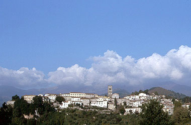

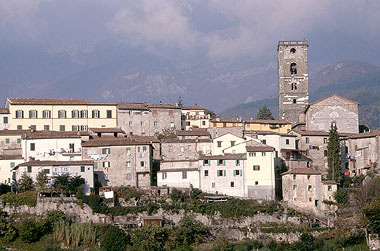
The fortified complex of Coreglia Anteminelli is on the highest part of an Apennine buttress along the steep banks of the torrents Ania and Segone; the village itself developed at the foot of the fortification following the morphology of the ground.
The rocca was in a strategic position controlling a vast portion of the valley; moreover from here it was easy to send light signals from here to the fortresses of Brancoli and of Motrone and, from there, directly to Lucca. The fortress was very close to the mountains, strategically important and almost impregnable; it could house a considerable number of soldiers with all their equipment. Like so many ancient fortresses, also that of Coreglia went through a series of transformations in time: its grounds were destined to agricultural activities and it became a residence, the walls were lowered and the balcony for the guards was taken away; it remains, however, on the whole impressive and preserves good part of its character of ancient fortification.
The rocca was in a strategic position controlling a vast portion of the valley; moreover from here it was easy to send light signals from here to the fortresses of Brancoli and of Motrone and, from there, directly to Lucca. The fortress was very close to the mountains, strategically important and almost impregnable; it could house a considerable number of soldiers with all their equipment. Like so many ancient fortresses, also that of Coreglia went through a series of transformations in time: its grounds were destined to agricultural activities and it became a residence, the walls were lowered and the balcony for the guards was taken away; it remains, however, on the whole impressive and preserves good part of its character of ancient fortification.
Coreglia Antelminelli
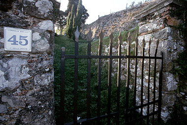
The enceinte is reasonably well preserved, though in some parts, owing to the use of the grounds for agricultural purposes combined with natural decay, they badly need repair.
Compared with the description we find in documents the wall appears lower and without patrol balconies and bulwark; instead, the tower was demolished in the 19th century so the stones could be reused for paving the village streets.
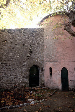
The complex later became private property and at present it is still a residence, while the land around it is used for farming.
Compared with the description we find in documents the wall appears lower and without patrol balconies and bulwark; instead, the tower was demolished in the 19th century so the stones could be reused for paving the village streets.
The complex later became private property and at present it is still a residence, while the land around it is used for farming.
The construction of the fortress probably dates back to the XIth century when the Rolandinghi family, who owned land in the middle valley of the Serchio between Barga and Calavorno, left their ancient fortress of Ansuco near Coreglia and retreated further up to a better fortified position. At the same time a new and safer fortress overlooking the village was built.
The rocca had an important military function during the battles conducted by Lucca against the municipalities of the Serchio valley; in 1316 the fortress was a stronghold of the Guelph resistance against Castruccio Castracani who eventually conquered the castle and reinforced its structure, including it among his defensive garrisons. In the first half of the 14th century Francesco Castracani, who often carried out raids into the neighbouring territory of Barga, used the rocca as a place for gathering his troops. For this reason he enlarged the fortress that, together with the tower of Ghivizzano , was his and his family's residence for long periods.
A steep graded ramp paved with cobbles leads up to the main gateway that in past was equipped with a drawbridge and a guardhouse. The rocca lies at the top of an Apennine buttress and is surrounded by impressive walls.
The fortress is irregular in shape owing to the morphology of the ground; on the east stands a residential building that incorporates previous military structures that were enlarged or transformed for this purpose, while on the southern side we can see, still well preserved, a bastion with loopholes connected to a smaller bastion on the northern side by a short stretch of curtain wall: together they formed a bulwark against enemies attacking from the surrounding mountains.
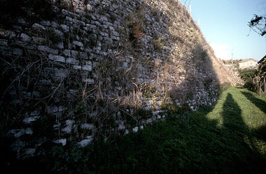
The walls were made of small ashlars arranged in neat rows, according to a technique widely used in the Middle Ages; they have a slight scarp on the southern side, while on the northern they are vertical because the ground is very steep.
On a lower level, to the south, we can see a stretch of wall connected to the walls of the village where the latter have a gate with guardhouse.
The rocca had an important military function during the battles conducted by Lucca against the municipalities of the Serchio valley; in 1316 the fortress was a stronghold of the Guelph resistance against Castruccio Castracani who eventually conquered the castle and reinforced its structure, including it among his defensive garrisons. In the first half of the 14th century Francesco Castracani, who often carried out raids into the neighbouring territory of Barga, used the rocca as a place for gathering his troops. For this reason he enlarged the fortress that, together with the tower of Ghivizzano , was his and his family's residence for long periods.
A steep graded ramp paved with cobbles leads up to the main gateway that in past was equipped with a drawbridge and a guardhouse. The rocca lies at the top of an Apennine buttress and is surrounded by impressive walls.
The fortress is irregular in shape owing to the morphology of the ground; on the east stands a residential building that incorporates previous military structures that were enlarged or transformed for this purpose, while on the southern side we can see, still well preserved, a bastion with loopholes connected to a smaller bastion on the northern side by a short stretch of curtain wall: together they formed a bulwark against enemies attacking from the surrounding mountains.
The walls were made of small ashlars arranged in neat rows, according to a technique widely used in the Middle Ages; they have a slight scarp on the southern side, while on the northern they are vertical because the ground is very steep.
On a lower level, to the south, we can see a stretch of wall connected to the walls of the village where the latter have a gate with guardhouse.
Scopri altre attrazioni vicino a Rocca of Coreglia
See all


You may also like..
See all
0