


In the IIIrd century B.C., after conquering southern Etruria, Rome turned its attention towards northern Etruria and formed alliances with single towns. Pisa, in particular, was for the Romans an important naval base in the northern Tyrrhenian and they soon discovered the strategic potential of the natural port in the estuary of the Magra.
The struggle for the control of the entire territory with all its landing places was the cause of the war against the local Ligurians that ended with the foundation of the Latin colony of Lucca (180 B.C.) and the Roman colony of Luni (177 B.C.).
The foundation of these two towns represented a turning point in the history of north-western Etruria that was henceforth rapidly and completely romanised. Of greatest importance was the net of consular roads linking the conquered territory directly with Rome and also opening it towards northern Italy. The area around the two towns was completely reorganised, reclaimed and divided between the settlers in this period. The Etruscans and Ligurians, after a strong resistance that lasted until 154 B.C., accepted the new order and became part of the new social order.
The period of the Republic was for the two colonies a time of progressive economic growth connected to agriculture in the territory of Lucca and to the activity of the ports, together with the intensive exploitation of the Apuan marble quarries, for Luni.
With the end of the social war (89 B.C.), Lucca and Pisa also became Roman municipalities; in 55 B.C. Lucca, still part of Gallia Cisalpina, hosted a well known meeting of the triumviri Caesar, Pompey and Crassus. After the civil wars, the territories of Lucca, Pisa and probably also Luni were newly colonised and the land assigned to the veterans of the triumviral or Augustean armies.
For the whole region the Imperial Age was a period of particular affluence: in the towns new monumental buildings were erected and merchants as well as artisans prospered.
Signs of crisis and change began to appear during the middle Imperial Age, particularly in rural areas where single scattered settlements were progressively abandoned and production was concentrated in larger centres.
Lucca, further away from the maritime trade routes, was more affected by the crisis of the IInd and IIIrd centuries A.D.; the merchants' activities declined, the whole urban fabric began to decay and numerous rural settlements were completely deserted.
Details:
With the Roman colonisation economic activity was focused on agriculture. So, while the surviving Ligurian population perpetuates its traditional woodland and sheep-breeding economy on the hills overlooking the coast of Versilia (La Cappella) or on the edges of the plain of Lucca and in the mid Serchio valley (Marlia; Ponte a Moriano), the agricultural reorganisation of the Romans takes root and occupies all the flat areas included in the "centuriazione" (Chiarone; Fossa Nera; Acquarella; Montiscendi; Cafaggio; Pieve di S. Giovanni e S. Felicita).
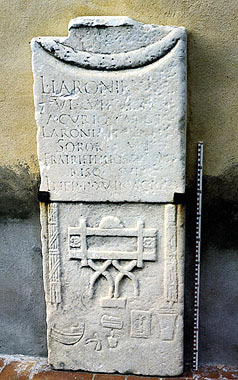
The numerous Roman farms are usually constructed with simple building techniques following the local tradition: walls were made of raw clay upon a stone plinth and there were tiled roofs and pavements of beaten earth or, sometimes, cocciopesto and bricks. The scattered agricultural settlements are reflected in small burial areas, usually associated with farms or modest rural hamlets (Pievecchia; Montiscendi; Cafaggio; Pieve di S. Giovanni and S. Felicita; Marlia).
Alongside the traditional cereal growing, wine and olive oil production also developed as we can see from Fossa Nera in the plain of Lucca and Acquarella in Versilia. During the Imperial Age, as we know from Plinius, Luni was famous for its wine and Pisa for its grapes.
The agricultural products were meant to meet the local demand in the inland areas, while, on the contrary, along the coast and in particular around Pisa, the manufacture of amphorae used for the transport of goods shows that wine was also produced for export.
The romanisation of the territory stimulated also the exploitation of woods and quarries that provided essential building materials for the new towns, where a number of monumental structures and rich houses were built, as well as for the shipyards in Pisa and Luni. There was, of course, also an early development of all the artisans' activities that were necessary to meet the needs of the new colonists, such as the production of household earthenware, black glazed pottery, terracotta panels, bricks and tiles.
Large scale enterprises were, instead, those that developed in the first Imperial Age, connected with the exploitation and trade of Apuan marble, based in Luni and with the production of terra sigillata italica tableware in the Pisan workshops.
The two large ports of Pisa and Luni, along with a network of smaller sea and river harbours, permitted, until Late Antiquity, an intensive trade in local products and raw materials towards the Mediterranean together with the import of a large number of goods.
The families most involved in the exploitation of the natural resources became very rich and influential, like the Venulei who built themselves a luxurious villa in Massaciuccoli, one of the most beautiful areas of Versilia.
In the Roman period north-western Tuscany possessed a close net of roads, both long distance and local roads.
Along the Tyrrhenian coast were roads connecting Rome to Liguria and crossing the Apennine towards Gallia Cisalpina. Portus Lunae was probably already reached by the Aurelia Nova in 200 B.C.; certainly it was on the Aemilia, opened between 115 and 109 B.C.
Within the territory Lucca was an important road junction: probably since the period of the Late Republic a consular route, known as Cassia or Clodia, connected Lucca with Arezzo and from there Rome on one side, with the coastline on the other (Circo MassimoMassaciuccoli). To the north, through the Serchio valley where a number of placenames such as Sesto di Moriano, Valdottavo or Diecimo derive from the mileposts along the road, ran the Lucca – Parma axis. Other roads departing from Lucca reached Pisa along the coast, avoiding the passage through the Monti Pisani, and Luni along the Freddana valley.
The system of land division ("centuriazione") used during the period of colonisation deeply influenced the landscape of north-western Etruria. Indeed, the division in regular blocks, called "centurie", using orthogonal axes (so called "cardi" and "decumani"), was put into practice with the construction of a network of canals and local roads. Inside the "centurial" plots, preferably near the roads, were the farms.
In Lucca the division of land in regular plots ("centuriazione") during the IInd century B.C. has left traces in the south and east of the town where we can still recognise the original 710 m. x 710 m. (i.e. 20 "actus" in Roman measure) squares. The Roman town of Lucca had a well defined centurial division and was oriented nearly exactly along the cardinal axes. In the plain of Bientina, close to Orentano, an ancient road has been explored: it represented a centurial "decumanus" and was equipped with a wooden bridge across one of the branches of the Auser.
Near the town of Luni we can see some traces of a probable land division in rectangular plots ("centuriazione") oriented along the same axes as those of the town. In the coastal strip belonging to the colony, probably up to the ancient course of the river Versilia, the territory presents evident traces (roads, canals, boundaries) of the standard land division in 710 m. x 710 m. plots aligned with the coast. It is still uncertain if this division was carried out immediately after the town's foundation in 177 B.C. or in the last decades of the Ist century B.C. during the second phase of colonisation. What is certain is that the "centuriazione" of Pisa's territory dates back to the latter period and shows the same characteristics as those found in Luni.